blending an assortment of thoughts and experiences for my friends, relations and kindred spirit

blending an assortment of thoughts and experiences for my friends, relations and kindred spirit
By Alison Hobbs, blending a mixture of thoughts and experiences for friends, relations and kindred spirits.
Showing posts with label Maine. Show all posts

Sunday, July 21, 2019

More about Maine

"Whenever I hear of places with names like Pretty Marsh, I wonder if there's another town called Ugly Swamp, just down the road." said a witty friend of ours, when he saw a picture I'd taken of the Pretty Marsh on Mount Desert Island in Maine last month. It was all attractive, though.

We landed at Bar Harbor airport, BHB, crossing the water on the final approach in what Chris calls "squirrel-y" winds (ahead of a storm front) after an exciting flight from Ottawa on Sunday, June 23rd, via Sherbrooke and Bangor. Sherbrooke to Bangor had taken half an hour less than estimated, because we'd been allowed a direct heading across the non-active Military Operations Area we might have had to avoid, and because of a tailwind of 50 knots, we'd made an unprecedented 150 knot ground speed. I'm glad the flight was that much shorter. It was turbulent up there, due to the gusts. The speed of our journey meant that we landed at BGR well ahead of our given arrival time at the immigration point. Fortunately, the border guard was friendly, allowing us out of the plane immediately and hardly glancing at our passports, let alone asking a heap of official questions. We appreciated that. The last hop from Bangor to Bar Harbor also threw us around in the air.

View from outside our room at the Acadia Sunrise Motel
BHB (officially named Hancock County airport) is actually 12 miles away from Bar Harbor, in a township called Trenton. Having studied the map before we came I had booked us into a motel hardly more than walking distance from the airport but a long way from anywhere else, so the first thing we did on arrival was to pick up a car. The rental was expensive, probably because many of their usual clients land in private jets to pop into their 35-room cottages on the coast, and can afford anything. The Acadia Sunrise Motel was not of that ilk, but the polite staff there gave us a room for $69 (US dollars) with a bath and everything else we needed, apart from breakfast; we drove into the "village" of Bar Harbor for that, down Bar Harbor Road, crossing the causeway onto Mount Desert Island, the largest island off the coast of Maine. We did this drive several times.

The island's rather odd name comes from the 17th century French explorer Samuel de Champlain who called it l’isle des monts-déserts when, sailing by, he noticed the bare, rocky summits of these hills, nowadays the Cadillac Mountain area of the Acadia National Park. Mount Desert has been a hideaway or playground for the wealthier residents of New England since the 19th century. In 1947 a great fire raged across the island forests, destroying most of the posh cottages; many were never rebuilt.

The Egg Rock Light
The bay we sailed across on June 25th (Tuesday morning) --- from the dock below the Atlantic Oceanside hotel, with a party of old folk on a coach trip from Pennsylvania --- is known as Frenchman's Bay. We were on a pleasure boat called The Acadian that took us round the Porcupine Islands, through calm water and, round a headland of Mt. Desert Island, into choppier water --- "It's like a roller coaster here sometimes!"  which inclines to make passengers queasy --- beyond which the open Atlantic could be seen. Woollen blankets on board kept the cold wind out. Swinging back round, with the waves calming down again, we headed toward the Egg Rock with the Egg Rock Light on it. Here was a colony of seals, flopping about amongst the seaweed and looking from the distance amazingly like smooth, pale brown rocks. I noticed a couple of those "rocks" shuffling into the water for a swim, but most were sleepy, too lazy for swimming, except for the young ones already in the water with their whiskered noses poking out. An American astronaut had been the lighthouse keeper's son, on this island. The commentator kept up his educational spiel from the top deck. Formerly a high school teacher, he did this with plenty of humour, lecturing about how a lobster gets into a lobster pot, demonstrating with a plastic model. "And if you examine its claws closely you can work out where the lobster comes from. Look, here we are: Made in China!"


Back at the islands in Frenchman's Bay, now sailing close to their cliffs, we could see that these rocks are stratified, with very ancient layers at the bottom, Precambrian. I don't know much about geology; that is what our knowledgeable commentator said. The rocks had formed into a natural bridge at one point. Early settlers tried to inhabit the islands, a good defensive position, but what they could do there, other than fish, was limited. Now they are called the Porcupine Islands because they look like those animals from a distance. The cliffs here and on the main island are the home of bald eagles; we saw several perching by their nests.

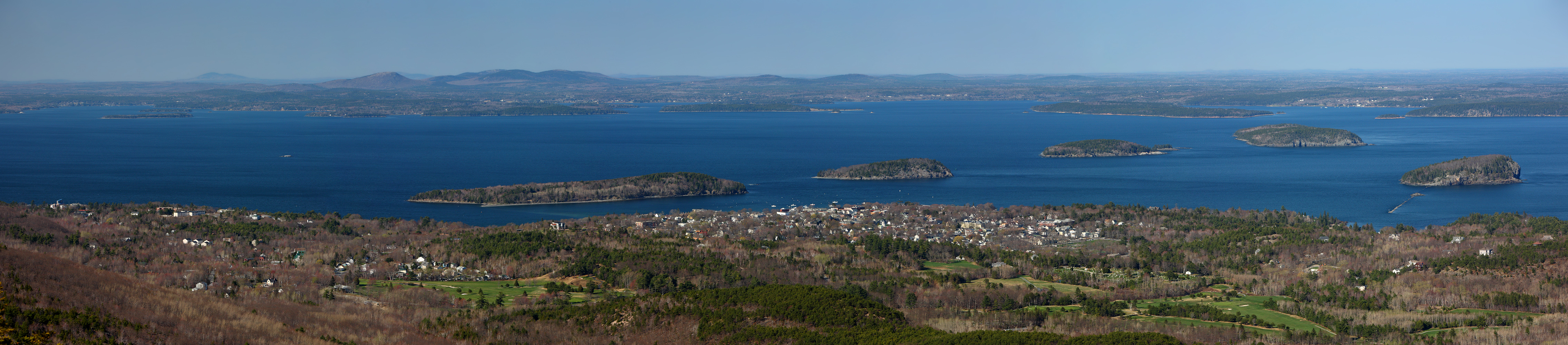
The Porcupine Islands, seen from above Bar Harbor (Wikimedia image)
At low tide, one of the Porcupine Islands can be accessed on foot. It's not a good idea to linger there for long. We saw the seabed starting to appear, at sunset on our third evening there.


Bar Harbour in the early evening
During the two days we were on Mount Desert Island, we explored it by car and on foot, Bar Harbor itself, pleasant to walk around, with its Shore Path, parks and gardens, well appointed eateries and so on, the beach at Seal Harbor, the small towns of Northeast Harbor and Southwest Harbor with their marinas, along the scenic road up Somes Sound and down the other side to Bass Harbor Head, where an old lighthouse stands on the rocks. We left the car there for a walk to the lighthouse, not much of a walk, and the rocks were crowded with sightseers. We did get the Pretty Marsh to ourselves until a party of kayakers turned up, but again could only walk a few paces along the rocky shore, no trails there.

At Seal Harbor, Mt. Desert Island, Maine

Road by Somes Sound
To hike properly, maybe we should have used the trails of the Acadia National Park, paying the hefty entrance fee and finding a parking spot, but as we could see from the lines of glinting vehicles visible on the roads there, this would have been difficult on this sunny day, perhaps impossible, certainly frustrating and time consuming, which was not what we wanted. We decided not to bother, and kept driving. It would be a good idea to return in the off-season, although that could mean encountering fog or high winds.

By the shore at the Lamoine State Park
We wondered if Elsworth would be worth seeing on the mainland, but there was not a lot there. In the end we discovered the Lamoine State Park, beyond Trenton, which did have a reasonable trail, allowing us a walk through the trees and parkland, at East Lamoine, where there was a deserted pebbly beach, a quiet campsite, and a jetty.

I have already described our return to Ottawa in a previous blog post.

Saturday, June 29, 2019

Back from down east (in the USA)

At the end of June 2017 we flew PTN to Yarmouth in Nova Scotia, as I recorded with great pleasure in this blog. This summer, again just before Canada Day, we took the plane across the border to the coastland of northeastern Maine, to spend a few days in the Bar Harbor area. As before, we flew through some beautiful but unsettled skies on both the outbound and return journeys. This post describes the home-bound legs.

Our route went clockwise, with changes of heading at the dots
Wednesday morning was a cool, foggy, wet one at Bar Harbor airport (KBHB). We waited till almost midday until the cloud began to lift (it was still raining, dripping in around the air vents) and took off on an IFR flight plan to enter the cloud at 300 ft above ground, on a heading of 040, not emerging above that layer until we'd reached 6000 ft, by which time we were well on our way to the beacon at Augusta. Never saw what Augusta looked like, down there. It is the state capital, not large. Before long, the unbroken whiteness did break up, as promised in the forecast, into cloudlets with blue sky above, and ahead of us was higher, summer cumulus. Our heading changed to a direct line from Augusta to KLEB, our destination, taking us at an altitude of 8000 ft through two or three MOAs (Military Operations Areas) which were inactive, fortunately, like the ones we'd flown through from Sherbrooke to Bangor, on Sunday. This route took us south of Mount Washington, the position of which we could deduce from the pile-up of cumulus above and around it. The mountain ridges beneath our wheels were steep and the summits rocky and bare, with cloud shadows in the forests.

Undercast breaking up

Cumulus building on the horizon, over Mt. Washington


Connecticut R. at White River Junction, from the Vermont side
Landing at Lebanon, KLEB, was easy, after a 15 mile visual, straight-in, final approach. I had informed the Granite Air Center FBO that we'd be arriving at that time (1:45 p.m.) and the girl at the desk had ordered a taxi to pick us up and take us to our hotel. The taxi was waiting as we rolled in; a ramp attendant helped us park and the taxi driver came straight up to our plane to load our very small amount of luggage into her car, thence driving us straight out onto the road. This saved us a good deal of time. She was an interesting person to talk to—taxi drivers nearly always are—she'd been born on a native reservation near Chicago, but liked her home on a hill by the Connecticut River, with human remains in her garden, so she claimed. This too was former tribes' land, with a native graveyard on her property. At Hallowe'en she makes the most of this, scaring the local children with "eyes" lighting up above the graves.

Main Stree, White River Junction
White River Junction, the locality of the hotel I'd chosen, turned out to be worth a visit. It's actually one of several little towns or villages that amalgamated into a town called Hartford, but on the Google map it's labelled West Lebanon. The other part of "Lebanon" is across the Connecticut River in New Hampshire. White River flows into the Connecticut here, and is brown, not white. The "Junction" refers to the two railway lines that have met here since the 1840s. Amtrak trains still carry passengers to New York and then Washington, DC, but that slow journey on The Vermonter takes over 11 hours, if you board at this station early in the morning. It would feel like a pretty long day. A gentleman talked to us at the station's Welcome Center, and told us about the trains and the town, how it has revived considerably since the 1970s, when the unemployment rate was around 40%. Nowadays, unemployment is at a very low percentage because the area has embraced modern technology (solar power, for example) and the arts (with several theatres, a college for cartoonists, galleries); medical and science institutions have been established in this region too. It seemed lively for a small place, buzzing with optimism. The town hall put on free concerts; the outdoor one we overheard went on for two hours! Next door to our hotel, a Turkish-American entrepreneur had established a restaurant, the Tuckerbox, where we ate well, served by a waitress from Kazakhstan, and a gift shop called Little Istanbul.

Hotel Coolidge entrance, with a thunderstorm coming
The Hotel Coolidge, was one of the oldest buildings in White River Junction. It has two square towers and a very long wing where the bedrooms are. We were given a sort of suite on the upper level: two bedrooms, one with a single bed, and a bathroom in the middle. Ideal for a three person family! The furniture, window fittings, hallways were old. The shower and its plumbing was ancient and erratic. We liked the place though; it had character. The hotel's owner-receptionist had a sealed-off area in the high-ceilinged lobby to herself. This morning she gave us a voucher form for our small breakfast at the adjoining coffee shop where the lady who served us was very insistent that it be properly filled in. I could have spent hours in that coffee shop, which had a sort of library in the corner and several issues of the New Yorker to read, but Chris wanted to get going with his flight preparations at the airport. The Granite Air Center was a comfortable spot too, mind, having Adirondack chairs by the big windows where you can sit and watch the action on the airfield, comfortable leather armchairs behind them in the rest of the room. There were historic news clippings and old photos on the walls and 1950s Coca Cola aviation themed adverts in a display cabinet. The FBO building has a completely solar panelled roof, installed a year ago, the output from which offsets a huge amount of carbon emissions, apparently a very successful idea. The receptionist gave me two miniature bottles of maple syrup as a souvenir when I paid for our Avgas.

Crossing the Canadian border (St. Lawrence River) into Ontario

So this morning we left Lebanon for Ottawa at 11 a.m. on a flight lasting 2 hours 15 minutes, via the RUCKY waypoint and the Burlington (BTV) VOR, before which we overflew Mount Ellen (4083 ft) and other peaks of the White Mountains. Cloud formation and development along our route seemed to be associated with the hills and lakes, in particular at the western edge of Lake Champlain where they grew larger and bumpier, gloriously white and bulbous from a distance, but with dark grey undersides and centres when you are in amongst them. Pilots of the large commercial planes were reporting "light chop at all levels" according to one of the controllers. We had filed to "climb and maintain 8000" but when I started complaining about the turbulence in the bubbly areas, Chris requested a descent to 6000' where we could just about stay below the flatter cloud bases. No thunderstorms in our vicinity earlier today, although as I write this in the evening, with rain falling, I can hear the rumbles of local storms. At lunchtime, there was obviously some "weather" over the Mt. Tremblant area in the distance beyond our right wing.
Clouds to the west of L. Champlain

Over the Massina VOR near the border, as we were handed over to Montreal Centre by the Boston Centre air traffic controllers, we changed our heading again, direct to Rockcliffe. The lower clearer air was also turbulent on that leg, for some reason, but we were congratulating ourselves on a most successful and enjoyable trip as we homed in to Rockcliffe. We made a dramatic arrival though. At the last moment, after touching down, we had a sudden flat tyre (or tire) and went bumpety-bump till PTN stopped in the middle of the active runway, necessitating an immediate closure of that runway (other pilots having to continue their overhead circuits for 10 more minutes) and Rockcliffe staff hastening across the field to make sure we weren't in too much trouble. We weren't. Chris had kept the plane well under control and had brought it to a stop at the edge of the grass. The inner tube had simply worn out. It was replaced by Pat and his team in the hangar straight away. Chris was shown the hole.

Flat tyre on landing!