blending an assortment of thoughts and experiences for my friends, relations and kindred spirit

blending an assortment of thoughts and experiences for my friends, relations and kindred spirit
By Alison Hobbs, blending a mixture of thoughts and experiences for friends, relations and kindred spirits.

Wednesday, August 13, 2014

Bill's walk in Bhutan

Back in June, our friend Bill invited people to his house to see a slide presentation on his trip to Bhutan. I prepared this blogpost then, but never published it till now.

He hiked there this April, on his own (because the other two people on the trek dropped out on Day 2) for two weeks, with a team of Bhutan guides, only one of whom spoke any English. Most of the expedition, arranged through Blue Poppy was on foot, though they rode mules occasionally. Bill learned some useful phrases in Dzongkha, and even learned a song in that language, which he sang to us!

The Canadians landed at Paro, on a flight from Bangkok that stopped at a small airport in India on the way, and from Paro they drove uphill for hours in a rattly jeep, to the start of their trek. Everyone has heard of Shangri-La, the fictional Utopia of the Himalayas, but what is not so commonly known is that "La" means a pass through the mountains. The altitude is so high that it is essential to know where the passes are. The Himalayas make Bhutan virtually inaccessible from the north and dense jungle makes it inaccessible from the south, so it's a self-contained country. Forests of toxic rhododendrons deter exploration; even the local people cannot find a way through them. In the summer the rivers flood and wash away the rickety bridges. Winter is obviously impossible for travelling. In autumn early snow is a great danger, so the only relatively safe time to see the wilds of Bhutan is in the spring, when Bill was there.

After the first night, as mentioned above, his Canadian companions fell prey to altitude sickness to such an extent that they had to turn back and go home. Camps on the trek allow one yellow tent for the westerners and another, less well appointed one for the guides. Bill felt lonely on his own in the yellow tent when his friends had left, so insisted on joining the guides in theirs. They squatted on the ground to cook, serve and eat. Bill missed access to beer and chocolate, he said. At night he found it hard to breathe, feeling as if he was suffocating, so kept suffering from insomnia.

The mountains, usually best seen in the mornings, were superb. The highest one in Bhutan, Gangkhar Puensum, 7,570 metres, has never yet been scaled, partly because the "climbing of mountains in Bhutan higher than 6,000 metres has been prohibited out of respect for local spiritual beliefs". There's a different attitude to tourism and mountaineering here than in Nepal. The guides cost far more, work for a fairer price (it costs $250 a day to trek over the passes) and so can support their families from their wages. 30% of the country's land is a conservation area. It has to be, to a large extent. Bill took a picture of 
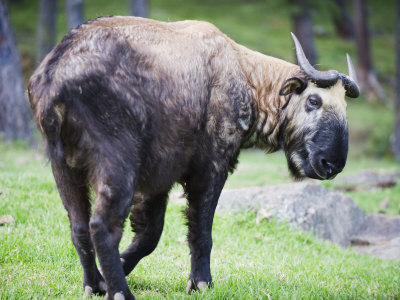
wild takin at close quarters, about the size of a small bison.

The long trek ended at a village that had hot springs and communal bathing in huts. He talked of a "mud field" and imagined the women's three day hike up and down a muddy trail when their babies due, and then returning a month later carrying the babies on their backs.

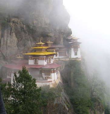
Tiger's Nest Monastery (Wikipedia)
The term "Gross National Happiness" was coined by the Fourth King of Bhutan, His Majesty Jigme Singye Wangchuck, to analyse the demographics and assess the wellbeing of his people, who mostly still wear traditional clothes (gho and kira); only jeans are now creeping in, too. Most Bhutan people are yak herders, who enjoy archery contests. They drink butter tea and chew betel leaves as a stimulant, leaving a red residue on their lips and teeth. It's probably addictive. The girls are shy, though at a certain age, boys come to them on night visits, climbing through open windows and finding the girl on her sleeping mat midst of family. There are jokes about finding the mother by mistake, but usually this practice establishes the young people as a married couple. Bill said he saw phallic symbols everywhere, as well as the prayer flags and prayer wheels. He showed us pictures of these, but the temples for prayer are considered sacred, where photography is not allowed. A giant buddha sits on the hillside overlooking the Thimphu valley, and Buddhist monasteries such as the Tiger's Nest near Paro are perched on sheer cliffs.

Tuesday, August 12, 2014

A natural glow

This morning I cycled into town to visit the current exhibition that's on the top floor at Ottawa's Museum of Nature: Creatures of Light, Nature's Bioluminescence. It's a wonderful show, enhanced by the other-worldly music that plays in the background (yes, for once I thought of background music as an enhancement!) and which in the subdued lighting causes visitors, even the children, to fall into a trancelike state of awe. Some small children there today even seemed a little frightened by the strange exhibits glowing in the dark.

Firefly, Photinus_pyralis (Wikipedia)
The explanatory detail is very well thought out and displayed, with just enough interactive screens to help you concentrate, and I like the way they have film clips of present day scientists talking about the excitement of their research. The museum has firefly carcasses embedded in plastic that you can turn over (to see their light-emitting parts) and magnify. Not many live creatures (or plants, or unclassifiable plant-creatures) are on display, but the ones that have been made available for viewing, mostly in the marine section of the exhibition, are fascinating. I spent a long time staring at the beautiful, gently moving corals and gleams of split-fin flashlight fish in a tank of unlit water (Do not shine iPhone lights at them or they might die! say the warning notices.) The small jelly fish swimming up and down in their tank likewise transfixed everyone who came by. The enlarged models of the creatures show you what to look for and where to look––otherwise I might have missed the delicately thin but deadly filaments under the body of the jellyfish.

Aequorea victoria (Wikipedia)
I was lucky to have arrived at the museum before most other people did, so that there was no pushing to look closely at the exhibits and no children being noisy or impatient. Later in the morning the queue for entrance tickets was quite long, probably because it had started pouring with rain. I went out to get back on my bike (with its wet saddle!)––enveloped in a transparent, portable waterproof, that billowed like a jellyfish as I pedalled home.

The colours of Ecuador

A party to celebrate Ecuador's National Day was held at the Ottawa City Hall yesterday evening, and I'd been invited, so joined in. Flags stood at the front. The children of the embassy were wearing the traditional dress of their country. Musicians from Ecuador were playing on pan pipes and percussion, deafening anyone trying to converse at that end of the hall, and speciality cocktail snacks were being handed out to the big crowd. The drinks table didn't only serve wine and mineral water; we had refreshing, mystery juices in jugs. After the national anthems of Canada and of Ecuador, followed by the Ambassador's speech, a full hot buffet opened, everyone lining up for Ecuadorian dishes made with corn, quinoa, beef, chicken and so on, most generous, and four pretty ladies performed a traditional dance amongst us, making the most of their full skirts––yellow blue and pink, with white ruffles. At the end of the reception each guest was given a trio of roses to take away with them, coloured like the country's flag.


At the reception I met people I know from a variety of other countries, including Iran, Korea, Mongolia, Britain. Graham from Britain asked me where I came from and when I told him N. Yorkshire, he wanted to know if I'd ever done the Lyke Wake Walk. I had ... long, long ago! It was strange, remembering that eccentricity in an South American context.

Sunday, August 10, 2014

Eddie and the steel pans

Eddie Alleyne, a musician from Trinidad and Tobago, who plays the steel pan drums in and around Ottawa, bringing his music to the children of Ottawa schools from time to time, came to play for Rockcliffe Flying Club members yesterday evening, under the gazebo near our Mile High barbecue. He's known as Eddie Steel-Pan, so Tony told me, Tony's own speciality being the barbecue. Last night (August 9th) he and his wife Joy offered a change from the usual burgers and hotdogs, bringing rice and peas with barbecue chicken or jerk chicken or chicken curry roti to serve. I had a substantial helping of the roti! Joy told me it had taken her all day to prepare those meals.

The moon rose as we sat at the picnic tables with our flying friends, enjoying the food and the music.

At the end of the summer we are going to have another such evening organised by Tony, when a jazz band is going to play for us. On that afternoon evening there'll be games and children's races and a flour bombing contest as well.

Saturday, August 2, 2014

Day 12: PTN, homing pigeon

Our whole route as recorded on the iPad's "Foreflight" application
We're back. North Bay wasn't our favourite stopping place because the hotel had a noisy air conditioner that kept us awake half the night; we have a few more complaints besides which I'll post on the Tripadvisor website. We were at the airport before 9 and (after PTN's engine made up its mind to start, being temperamental again for the first time since we'd left home) could take off for Ottawa-Rockcliffe before any clouds developed.

Little clouds over the hazy Algonquin Park
We had hardly any wind at ground level and a little tailwind at altitude. We flew in hazy conditions again, across the Algonquin Park, past the old radio telescope by Lake Traverse and, avoiding the military airspace around Petawawa, to the Killaloe VOR near the cottage country at Bonnechere, Round Lake and Golden Lake, where we turned slightly left onto the airway that leads to the YOW beacon. The Ottawa River beyond Pembroke was out of sight in the haze with morning fog in the valleys behind it, and on the last stretch of the journey, it was hard even to make out where Arnprior was, though we were just the other side of the Ottawa River from there. ATC kept us "no lower than" 4500ft on the Quebec side until we had almost reached the city, before allowing us to descend to very familiar territory and swoop in to Runway 09 at CYRO like a homing pigeon, Chris allowing PTN to do a rather steeper turn than I'd prefer over the Montfort hospital in order to enter our home circuit from the south.

A familiar view!
Too many other aircraft at the pumps so we've postponed the refuelling––no more flying this weekend! We tied down, unloaded the luggage, forgetting the bag of dirty laundry in the back that we'll have to fetch tomorrow, and went to sit in the shade under the gazebo with Tony before he fired up his barbecue. After a while Laurie joined us too; Chris chatted to the men while I finished reading the last couple of chapters of a Howard Engel whodunnit (set in a fictional St. Catherine's at the west end of Lake Ontario) that I've been reading on this trip, where the detective unravels the plot and ties all the loose ends together.

Here are the statistics for our trip:

Engine on-time: 30.2 hours
Time in the air: 27.3 hours
Total distance flown: 2494 nautical miles (4619 km)
Average speed: 91 knots (169 km/h)


Friday, August 1, 2014

Day 11: islands in the mist

The sales manager of the Prince Arthur drove us to the airport herself, in the courtesy car, telling us of her hopes for Thunder Bay and her hotel. They're close to the U.S. border so are always hoping for American tourists to create a livelihood.

Chocks away at the F.B.O. and an easy take off from the intersection of taxiway Bravo with Runway 25. We were flying VFR again, in the hope that the morning fog would have lifted sufficiently for us to land 220 km away at Marathon. There was no fog in sight at the start of this flight; we had an unimpeded view of the water beneath our wheels and our lifejackets on, again. We were flying last week's route in reverse, along the line of islands to avoid the straight line across Lake Superior, and as we began to veer east we did notice the sea of low lying fog ahead, with islands sticking out of it like lumps of pudding in white custard; actually it was far more beautiful than that and I did my best to get some good photos. The reflections in the window pane frustrate me though. Not until the last 20 miles did we realise that Marathon airport would be in the clear; otherwise we'd either have had to fly on to Chapleau without stopping or return to Thunder Bay!


Chris refuelled at Marathon, knowing how to work the self service pump this time but still getting his hand trapped when recoiling the big hose. Flying's a hazardous occupation! Fortunately a lady was at work in the airport who could tell us which direction to take along the highway to find some lunch at a gas station restaurant, so we didn't need to unpack our emergency pot noodles and search for a kettle. And the walk stretched our legs.

For the next, longer leg, were cleared to North Bay airport via YSP AR16 YLD RR10 YSB V316 YYB at 7000 ft, which meant we would be travelling nearly the whole route in uncontrolled airspace. With no internet access at either the restaurant or airport in Marathon, Chris had had to phone for an old fashioned flight briefing from Winnipeg flight services, and I'd only heard his side of the conversation, so wasn't sure what to expect in the way of clouds en route. They were small and low enough to start with, and we were soon through and above them on our climb to 7000, but after about 20 minutes the clouds began to climb too, and then we were disconcertingly in and out of the tops for miles. When in the clouds it was bumpy flying. Our few moments' respite between clouds were in smooth air. As we progressed, the clouds got higher and bumpier and more joined up, though I kept hoping for them to thin out, and they did for a while, around the half way point above Chapleau. Over the airwaves though, we were beginning to hear the voices of other pilots in planes large and small finding themselves in difficulty to the south, especially around Toronto, because big storms were building there.

North Bay with TCUs to the east of Lake Nipissing
The city of Sudbury with its famous nickel mine chimney came in sight 2 hours 20 minutes after our take off from Marathon, and then we turned left and said to one another, we're nearly there (at North Bay). But we had a biggish cloud ahead on our own route and despite the fact that ATC had allowed us to start our descent there was nothing for it but to go through the middle where it was raining heavily, dark and turbulent (probably towering to about 10000ft, not much more). Chris delights in these challenges, but I don't so much, and what it would be like inside a fully grown towering cumulus I don't like to imagine. We were probably only in that cloud for about 10 minutes and Chris was managing to look up waypoints on the computer and talk to ATC and so on while I was clinging on to the strap and making complaints. I hope he just ignores me. What a relief to come through to the Other Side and see Lake Nipissing and North Bay and, indeed, the airport ahead, all in sunlight and calm Visual Meteorological Conditions. We'd been cleared for the VOR / DME approach to runway 26 via DAVUM but didn't need it because we'd got clear of the clouds.

PTN (the C172 on the right) with larger aircraft at CYYB
After we landed two Westjet Boing 737s landed and taxied onto the ramp behind us having been diverted from Toronto. The passengers all had to stay on board. Chris and I could get out of our own plane and now we're at one of the Travelodge hotels in North Bay, and I'm going to have a swim in the pool. We ate at Wacky Wings this evening where you'd be able to wear what looks like a dead chicken on your head if it were your birthday party.

Day 10: Thunder Bay, again

(Thursday, July 31st)

View from our hotel room in Thunder Bay
We were intending to be in Kapuskasing or Geraldton this evening, but it wasn't possible. Needing to fly IFR because of the weather ahead, Chris was legally obliged to file a flight plan including an alternate airport at the destination, and there were none accessible. We looked at places ahead of Geraldton and north of Geraldton; they were all too far to reach with the remaining fuel on board. The obvious alternate was Marathon, south of Geraldton, but that was socked in with fog, below minima, in fact reporting 0ft vertical visibility and 0ft horizontal. Even if we had been able to approach Marathon and land there, we wouldn't have been able to watch the sun set over the islands in  tonight's rain. So it's just as well we have returned to Thunder Bay where the weather has been fine all day.

On our way to Kenora airport after breakfast we saw three deer. The taxi driver told us they have moved closer to the edges of town because of their predators in the forest, the timber wolves. The driver asked where we came from and told us proudly of his granddaughter who has just graduated from Cambridge university-- he'd been to England to see her.

We took off from runway 08, i.e. in the right direction, cleared to the VOR at Sioux Narrows on the eastern side of  Lake of the Woods, and thence direct along V300 to Thunder Bay. At first, especially, in thick haze at 7000ft, our GPS navigational aids were most necessary. The only landmark apart from the occasional view of the trans-Canada highway or railway was the town of Atikokan, at about half way, which had an airport and a non-directional beacon (NDB). The approach controller at Thunder Bay gave us vectors for a visual approach to runway 25 at the destination, where it was fine and clear, as reported ... and windy. When he handed us over to Tower, we were told to expect a landing on runway 30 instead (with 20 knot gusts) because the wind direction had changed.

The Thunder Bay marina, our hotel in the bottom right corner
Maintair, the Shell FBO, gave us good service on arrival, even booking our hotel for us at a considerable reduction on the price we paid last time. It's a better room too, with two double beds, an armchair, desk, plenty of space and the glorious view out of both windows. Downstairs there's a swimming pool at our disposal. Hotel slogan: "The only thing we overlook is the waterfront." All this for $89! This afternoon, Chris and I sat by it again, walked around the Spirit Park, etc., found a good supper at a Thai restaurant, and did another circuit of the higher part of town. All the time, our eyes are drawn to the lake and the sky.