 July 21st
Written en route from San Francisco to Charlotte over the eastern end of the Nevada and Colorado deserts. We're in cloud; either we're flying low or this cloud is very high, probably the latter. It has been a noteworthy flight so far, with views of the long bridges over San Francisco Bay, of Oakland airport, the coastal ridges with their pale grassland, and the flat San Joaquin Valley, then the Sierra Nevada, beyond which are desert sands and rocks with occasional salt pans. At times, no roads are visible. Now we're emerging from the desert area, over Utah or Colorado, I think; I could see what looked like the Colorado River just then, flowing south and cutting deep canyons in the landscape.
During the last two days, we've been travelling around on the ground, in a car rented in San Pablo. Chris had finished work (talking about software for medical robots) on Wednesday, so successfully that his presence will be required in California again before the summer's out. In order to relax we drove across the Richmond Bridge to the Sausalito side of the Bay, twice making the mistake of joining the freeway in the wrong direction. so that we had to backtrack and try again. Not so relaxing after all, with the big trucks to contend with. Once off the busiest roads, heading in a more appropriate direction towards the Mt. Tamalpais State Park on Highway 1, we found a narrow road with with precipitous bends leading to Muir Woods. Chris didn't mind this kind of driving but it made me nervous, especially as some sections of the road had collapsed, reducing it to a single lane for traffic in both directions.
 Muir Woods, justifiably well advertised as a place of wonder, had plenty of visitors, but parts of the trail system were quiet. The giant redwood trees there (Sequoia sempervirens) grow more than 100m tall. Birds were calling, but we didn't spot any animals other than dragonflies until reaching the café at the end of the trail where a chipmunk took an interest in our sandwiches. A stream that runs through the steep, mossy forest hardly seems to supply enough water for all that vegetation; in fact much of the moisture comes from that misty cloud we kept seeing, that's formed by damp air rising up the hillsides near the ocean. The phenomenon is known as fog drip. Tourists were taking photo after photo of the trees, especially in Cathedral Grove, awed by the size and age of them, but it's impossible to get adequate pictures.
 |
| Highway 1, between Muir Beach and Stinson Beach |
 |
| A blur of vineyards, on the way to Napa |
 |
| Painted on a wall on First Street, Napa: famous inhabitants |
To reach these places, unless you're an extreme sort of cyclist, it's obligatory to use a car and pay the tolls to cross the impressive bridges over the estuaries in the Bay. We risked a detour up the Napa Valley on Friday afternoon to see the famous vineyards and the rocky, Provence-like hills above them, but nearly didn't get our rental car back in time because of the slow-moving traffic on Highway 29 ... luckily we picked up speed on the I-80, the main road from Sacramento.
 |
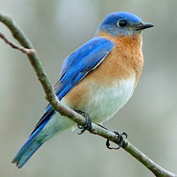
| Wikipedia picture of a bluebird |
We never made it to the Golden Gate Bridge ferry ride we'd planned for Friday, due to trouble with our on-line bookings and the printing of our boarding passes for this flight. The hotel's computer, running a Microsoft OS, kept breaking down and held us up too long to catch the boat. Never mind. It was a satisfying trip, even so.

2 comments:
-
You mention bluebirds. I strongly recommend you spend 11 minutes and watch this.
http://www.nfb.ca/film/to_be/
A bluebird features in the song at the end.
I wish more people would leave you comments.
Post a Comment